I haven't had any time to make this into a Lux map, but I think it would be a good one. Anyone else interested in working on it?....
The Vinland Map purports to be a 15th century map depicting Viking exploration of North America centuries before Columbus. If genuine, the Vinland map is one of the great documents of Western civilization; if fake, it's an astonishingly clever forgery.
Here is a link to a high-res JPEG of the original map to work from:
http://www.econ.ohio-state.edu/jhm/arch ... cmx02c.jpg
I am a big fan of alternative history and there has been a lot of recent evidence uncovered to support the idea of an ancient European migration into NA and SA (genetic and archealogical evidence that supports this map as being possible). The ol' Bering Land Bridge theory is looking recent and implausible to explain the complete timeline of Native American populations. No doubt, it will be another big year in 2005 for this topic!
Best Regards,
Sasquatch
Map Suggestion - Vinland!

Come on Sas, I went through the trouble of adding this
http://sillysoft.net/wiki/?LuxMap%20Requests
then you go and ignore it. Sheesh.
∞ mbauer throws a rock at Sasquatch ∞
Seriously though it looks pretty cool. I would take up the challenge if I didn't have 3 maps in the works already.
mbauer
http://sillysoft.net/wiki/?LuxMap%20Requests
then you go and ignore it. Sheesh.
∞ mbauer throws a rock at Sasquatch ∞
Seriously though it looks pretty cool. I would take up the challenge if I didn't have 3 maps in the works already.
mbauer


-
sasquatch

- Semiholy Beast
- Posts: 2876
- Joined: Mon Feb 09, 2004 11:35 pm
- Location: mountainous & wooded areas
- Contact:
MB,mbauer wrote:Come on Sas, I went through the trouble of adding this
http://sillysoft.net/wiki/?LuxMap%20Requests
then you go and ignore it. Sheesh.
The Halls of Lux are getting too grand for my simple mind. I didn't see this Wiki page until you posted the link, but I will make a contribution on it in the future.
If any other map maker wants to tackle this project, I will gladly trade and agree to protect your children up thru Middle School (daily walks to the bus stop, online advisor, lego & lincoln log playmate, etc...).
Thanks,
Sasquatch
-
sasquatch
- Semiholy Beast
- Posts: 2876
- Joined: Mon Feb 09, 2004 11:35 pm
- Location: mountainous & wooded areas
- Contact:
hi Jorge,
That would be great if you could make it happen. I was thinking that the map might stay true to the time period. That means no fleets and no connections from the west across the Pacific to east (Northern Euro-centric?). It should ideally have high continent values for Norway and lesser values for outlying areas such as Vinland (North America), Africa, and Asian countries. Ex: since NA is somehwat isolated it would make for better play to keep the value low, Norway has many borders so its high value would be more difficult to defend. I can't translate all of the text since I am not as familar with the gothic vocabulary as I would need to be to do that. I can help guide you though. Do you want suggestions for continent divisions with suggestions for the country/territory names? The modern names might make people understand what they are looking at so I would encourage using them instead of the Gothic names. Let me know what you think.
Thanks!
Sasquatch
Ready
Ok, I've prepared a background (900x545) that looks acceptable. So now comes your part... I would like suggestions for continent divisions, and everything else you mention in your last post. In essence, where would you like the lines drawn? What do we call everything? What are our values? Let's make this truly collaborative. I'll draw, you dream. What about all those little islands, for example? Individual countries?

-
sasquatch
- Semiholy Beast
- Posts: 2876
- Joined: Mon Feb 09, 2004 11:35 pm
- Location: mountainous & wooded areas
- Contact:
hi Jorge,
Here are the initial continents I came up with....
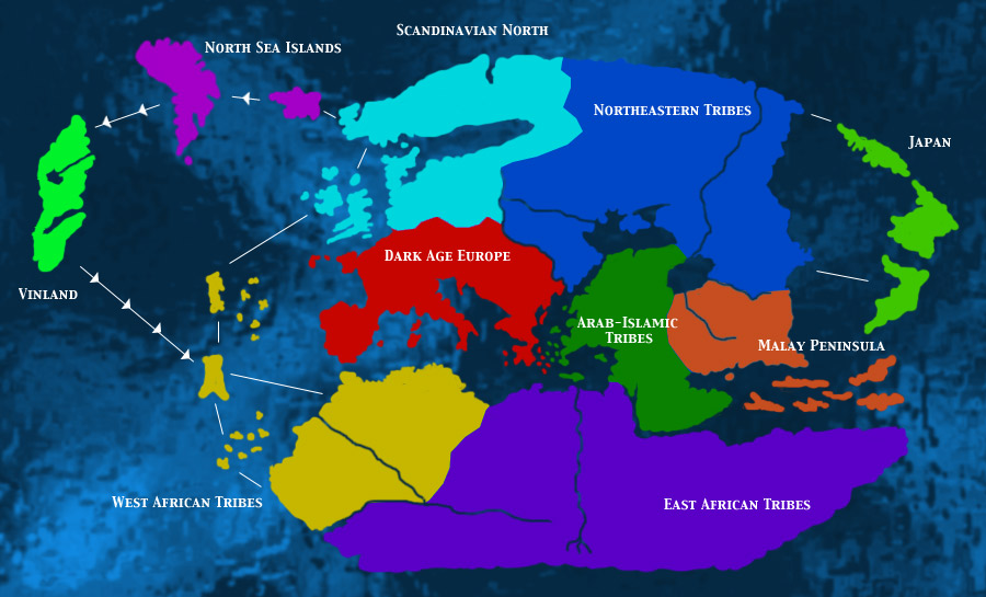
I changed some of the original map geography to "tighten up" some of the island clusters and make them cleaner. I thought it looked cool to leave in the major river systems so I carved them out. The routes are one-way to and from Vinland to take into account the prevailing winds. Do you have any comments or suggestions? I'll get the names of the territiories to you next.
Sasquatch

Here are the initial continents I came up with....
I changed some of the original map geography to "tighten up" some of the island clusters and make them cleaner. I thought it looked cool to leave in the major river systems so I carved them out. The routes are one-way to and from Vinland to take into account the prevailing winds. Do you have any comments or suggestions? I'll get the names of the territiories to you next.
Sasquatch
Excellent. I will adjust the background to add rivers and make sure I carve them out of the countries. Bridges? Do you want to do bridges like Castle Lux, or are the rivers there just for looks?
What about country suggestions? Do you have specific ideas of how you want each continent carved up into countries?
Now we're cooking.
What about country suggestions? Do you have specific ideas of how you want each continent carved up into countries?
Now we're cooking.
-
sasquatch
- Semiholy Beast
- Posts: 2876
- Joined: Mon Feb 09, 2004 11:35 pm
- Location: mountainous & wooded areas
- Contact:
hi Jorge,
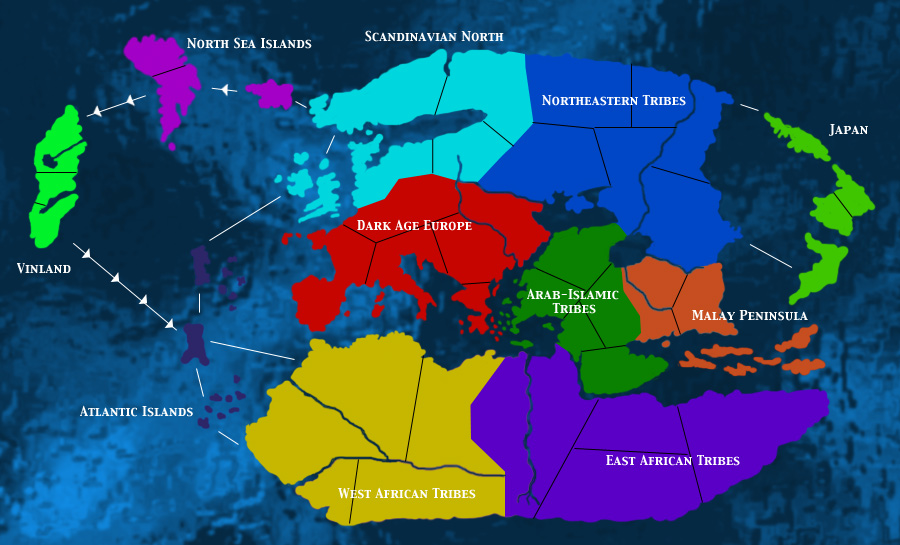
I haven't finished my research on naming the territories, but here are 3 separations of the map as it is now.....
Full Vinland Map
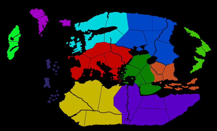
Territories Only
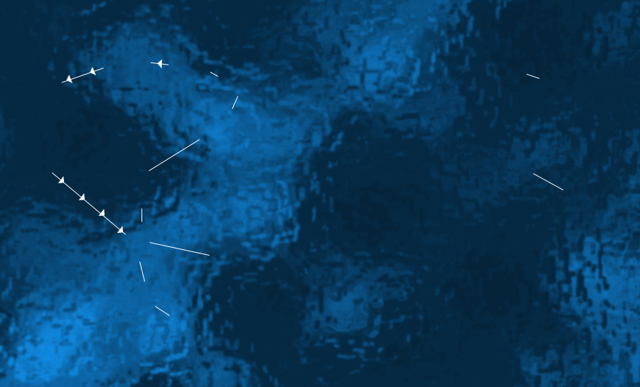
Background
I adjusted some of the country borders and added the territory borders. This is probably enough for you to begin assembling it and perhaps you use numbers for the territory names for now. It might be getting too big, but the idea is a map that is larger than classic without being excessively large. Let me know what you think and feel free to modify anything as you wish.
Sasquatch
I haven't finished my research on naming the territories, but here are 3 separations of the map as it is now.....
Full Vinland Map
Territories Only
Background
I adjusted some of the country borders and added the territory borders. This is probably enough for you to begin assembling it and perhaps you use numbers for the territory names for now. It might be getting too big, but the idea is a map that is larger than classic without being excessively large. Let me know what you think and feel free to modify anything as you wish.
Sasquatch
-
Zogu

- Luxer
- Posts: 48
- Joined: Sun Jan 16, 2005 1:22 am
- Location: Le Bic / Rimouski, QC, Canada
- Contact:
The Norse had strong contacts with Slavic tribes... these trading routes were dotted with outposts, which became the core of the original Russian people & culture.
The also had ties with Byzantium (this empire hired Norse mercenaries for the imperial guard... and also suffered a few naval attacks by Norse ships reaching the Black Sea by following Russian rivers).
At the time of the Vineland chronicles (let's say between 900 and 1200), there were no "arabic tribes" in mesopotamia; this land was bitterly founght by the Turks and the Byzantian orthodox christians. So the boundaries depends heavily on the exact century you chose. At around 900, Byzantium holds all of actual Turkey, up to Armenia. After the Mantzikert battle (disaster), about 50% of Mesopotamia falls into the hands of the Turks. The Turks gradually gain the upper hand and by the time of the 4th Crusade, the Byzantians only hold the city of Constantinople, Trebizonde (on the Black Sea) and a few fortresses in Achaea (Greece).
In fact, even though there were 2 raids on Constantinople by the Arabs, the land east of Greece has never been occupied by arabic; today it's Turkey, and thus populated by Turkish people. The fact that they are "Muslims" doesn't make them "Arabs".
Other regions that had active ties with the Norse were: Sicily & Southern Italy (both suffered raids by the Norse), Northern France ("Normandie", aka Norse Man Land).
(Venetia should also be present as a major power in your map. Other mahor powers should be the Turks, the North African pirate states / Muslim kingdoms, Germany's Holy Roman Empire, and so on. England is still a stinky mess, split it two by French rule in the south, Norse outposts in the north.)
I think that if you want to be historically sound, you must take these facts into account.

-
sasquatch
- Semiholy Beast
- Posts: 2876
- Joined: Mon Feb 09, 2004 11:35 pm
- Location: mountainous & wooded areas
- Contact:
hi Jorge,
I think it would be much better to retain many of the islands that you have eliminated in the last step. It isn't necessary to have each territory as a singular shape. A cluster of islands can still be a single territory. The islands around Greece & Turkey, Malaysia, and the Atlantic Islands just don't do it for me as they are here. On the positive side, the original map background and the overall look of the continents is very good!
Sasquatch
-
sasquatch
- Semiholy Beast
- Posts: 2876
- Joined: Mon Feb 09, 2004 11:35 pm
- Location: mountainous & wooded areas
- Contact:
hi Zogu,Zogu wrote:And by the way, a Viking (Norse) map shouldn't be set in the 15th century... but between 900ad and 1200ad. After that, the Norse fell into a sharp decline (mostly due to climate change, conversion of their kings [notably king Knut] to Christianism, and stronger states in Europe).
Thanks for the info! As you probably know, the "Vinland" map was supposedly drawn in the 15th century and it seems to reflect hundreds (maybe thousands) of years of accumulated information. I am aware of the perceived historical inaccuracies in the current continent names. I chose to stage this battle to ecompass the era of about 500-1000 AD... when there were most certainly Arab-Islamic tribes fighting in the Middle East. In the tradition of Amerigo Vespucci, I exercised my own biases and therefore choose not to recognize the "Byzantine Empire" as it's own continent. I am also thinking that this needs to be a playable map so the continents were constrained to just eleven total. The territory names will reflect more of the players at this broadly selected time period (Byzantines, Slavs, Goths, Vandals, etc..). I am open to specific suggestions for alternative continent names or for the territory names.
Sasquatch
-
Zogu
- Luxer
- Posts: 48
- Joined: Sun Jan 16, 2005 1:22 am
- Location: Le Bic / Rimouski, QC, Canada
- Contact:
Yes... I know it makes sense. Maybe I'm just being extra picky. 
It just feels strange not to have the "usual" empires from that era (the Byzantine empire was the strongest empire in the "known" world, that is, excluding China and the Aztecs). Especially since the biggest political games at the time were played by the Byzantines, the Church States and Venetia. That led to the disastrous 4th crusade, and so on.
The Viking era (900-1200) was also a great time for blood-thirsty emperors and conquerors: the Mongols, the Bulgarians, the Turks, and so on. Must have been very fun for Mister Poor Farmer living in Smalltown, Greece. (Why am I laughing now?)
About the Arabic tribes, well, it really depends what you call "Middle East". Except for a few raids in the 8th century, no arab army really moved north of Syria. The area was populated by Greek-speaking byzantine subjects, mixed with a few armenians. Later, after the battle of Mantzikert, the Turks gradually took over.
As for the Arabs, they never had the chance to move north, because of the strong turkish presence. After their initial (and sweeping) success in north Africa and Iran, the ethnic Arabs were stopped by the Turks (and also by the Mongols); after Turks converted to Islam, however, Islam move north at a tremendous speed... but it was carried by the ethnic Turks. By 1492, the Turks covered all the area from Lebanon to Vienna... they even managed to control Mecca and most of the Arabic states (with the notable exception of Morocco).
As for most of the well-known islamic figures in the 14th to 17th centuries, they were either Turks (lots of Seljuk and Ottoman emperors), Iranian (Suleiman), Mongol (Ulegu Khan) or Kurdish (Saladin). The Arabs, fierce warriors of Islam, became just that -- warriors, not political masters.
How ironic.
It just feels strange not to have the "usual" empires from that era (the Byzantine empire was the strongest empire in the "known" world, that is, excluding China and the Aztecs). Especially since the biggest political games at the time were played by the Byzantines, the Church States and Venetia. That led to the disastrous 4th crusade, and so on.
The Viking era (900-1200) was also a great time for blood-thirsty emperors and conquerors: the Mongols, the Bulgarians, the Turks, and so on. Must have been very fun for Mister Poor Farmer living in Smalltown, Greece.
About the Arabic tribes, well, it really depends what you call "Middle East". Except for a few raids in the 8th century, no arab army really moved north of Syria. The area was populated by Greek-speaking byzantine subjects, mixed with a few armenians. Later, after the battle of Mantzikert, the Turks gradually took over.
As for the Arabs, they never had the chance to move north, because of the strong turkish presence. After their initial (and sweeping) success in north Africa and Iran, the ethnic Arabs were stopped by the Turks (and also by the Mongols); after Turks converted to Islam, however, Islam move north at a tremendous speed... but it was carried by the ethnic Turks. By 1492, the Turks covered all the area from Lebanon to Vienna... they even managed to control Mecca and most of the Arabic states (with the notable exception of Morocco).
As for most of the well-known islamic figures in the 14th to 17th centuries, they were either Turks (lots of Seljuk and Ottoman emperors), Iranian (Suleiman), Mongol (Ulegu Khan) or Kurdish (Saladin). The Arabs, fierce warriors of Islam, became just that -- warriors, not political masters.
How ironic.
Yes, now I see how you can make a cluster of islands be one country!!
Dangit, I didn't even think you could do that... but it is a simple matter of putting a bunch of polygons in the same country tag. DOH! Well, I learned something new thanks to this project! I thought the islands looked like dogpoopoo, but I didn't know how to make them any other way... hehehe.
Listen, I've run into a snag with my free time. I'll be moving in to my new house next week, or two, and probably won't be settled in for a good month. How about I send you all the stuff that I've done so far and you finish this project up? You sound like a more experienced mapper than me anyways! Do you have access to Photoshop? I can send you the original Photoshop file with the layers for the map so you can change the text as it suits you, etc. etc.
Send me an e-mail to jorge-at-salasnet.com and I'll get everything zipped up for you.

Who is online
Users browsing this forum: No registered users and 29 guests